- General Philippines Map
- Map of North Philippines
- Map of South Philippines
- Palawan Map
- Bohol Map
- Other Philippines Maps
- Hand-made Philippines Map

| ||||||||||||||||||||||||||||||
|
Map of Philippines and
|
||||||||||||||||||||||||||||||
"How to travel around north and south, as well as
Philippines Map and Regional Maps of
Palawan and Bohol Islands"
All information below is subject to change
In this article you'll find:
Then you will need a good map to plan your backpacking trip!
In this post I've created a selection of useful maps of the Philippines, divided into regions (north and south) and popular islands (Palawan and Bohol). Most of them are from Google.
Questions I will answer are:
How to travel from Manila to north Luzon (Baguio, Sagada, Banaue, Mt.Pinatubo and other cities)?
How to travel from Manila to the islands in the south?
How to travel from Manila to Boracay?
At the end of this post you'll find a hand-made country map which I've created just for you.
Map of Philippines
First a general Philippines map:
Show bigger map
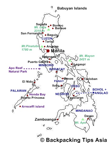
Map of North Philippines
Show bigger map
Your starting point to north Luzon will most likely be Manila. Most international flights land at the Manila International Airport: Ninoy Acquino.
From Manila there are many buses plying the route between major cities in the North.
Bus companies have terminals either in the Pasay area of EDSA (Manila), in the south, or at the northern end of EDSA in Cubao. Buses from Pasay terminals usually go south, and from Cubao usually go north.
Victory Liner bus company covers this route from Cubao: Baguio - Dagupan Lingayen - IBA Olongapo Alaminos Bolinao.
From Pasay City the same bus company covers: Olongapo Baguio - IBA Lingayen Guagua Pampanga - Cagayan Valley (Tuguegarao).
Want to take a day trip to Mt. Pinatubo?
| Route |
Fare
|
| Pasay City - Baguio |
440 PHP
|
| Pasay City - Tarlac |
186 PHP
|
| Pasay City - Lingayen |
339 PHP
|
| Pasay City - Dagupan |
318 PHP
|
| Pasay City - San Fernando |
109 PHP
|
| Pasay City - Manaoag |
307 PHP |
| Pasay City - Santiago |
359 PHP |
From Manila Baguio/Banaue - Sagada
The two most common ways of traveling from Manila to Sagada is either via Baguio (7 hours), or via Banaue (9 hours).
From Baguio there's another 2 hours to get to Sagada. From Banaue to Sagada it takes 4 hours.
As far as I know there are two bus companies travel to Banau: Dangwa Tranco and Autobus, both located in Sampaloc in Manila City.
| Route |
Fare
|
| Sampaloc - Baguio |
450 PHP
|
| Sampaloc - Banaue |
500 PHP
|
| Baguio - Sagada |
200 PHP
|
| Banaue - Sagada |
250 PHP |
You can also hire a minibus if you're on a short time-line. This is the most common and efficient way of getting around for "foreign" Filipinos.
But I warn you, the Filipino drivers are insane and they drive so fast that the only thing you can think about is whether you'll survive or not.
They drive fast even it's heavily trafficked, and in my opinion they're a lot worse than the worst Thai drivers.
Tip: If the driving is mad, don't be afraid to tell the driver. Tap him on the shoulder, and ask him to drive slower.
If he doesn't do that, a little payment usually helps to slow him down.
Map of South Philippines
Show bigger map
Traveling by ferries and boats are of course the most common way of traveling between the islands in the south.
Where in Manila is the harbor located?
Most ferries depart from the North Harbor (Manila) where you can buy tickets. If you want to buy ferry tickets in advance without going all the way to the harbor, you can buy them at travel agents in Ermita and Malate.
Negros Navigation company can take you to: Bacolod, Cagayan de Oro, Cebu, Dipolog, Tagbilaran (Bohol), Iligan, IloIlo, Ozamiz and Zamboanga (Mindanao).
Manila to Boracay:
If you have a lot time on your hands, taking the ferry might be an option. It can also be cheaper, but always check flights from Manila to Boracay first, before considering ferries. Have in mind that it takes approximately 25 hours to get to Dumaguit in Panay (nearest port to Boracay from Manila).
Superferry does trips to Dumaguit from Manila. From Dumaguit take a bus or jeepney to Caticlan which is the jump-off point for Boracay.
PS: Dumaguit (Panay) and Dumaguete (Negros) are two different cities, located in two different islands.
From Caticlan take a banca to Boracay island (20 minutes). It drops you off at Cagban Jetty on the Southern end of Boracay.
The nearest airports to Boracay are in Caticlan and Kalibo.
Other destinations Superferry serve, from Manila: Bacolod (7-10 hours), Butuan City, Cotabato, Cebu (12 hours), Cagayan de Oro (33-42 hours), Davao, General Santos, Iligan, IloIlo (19 hours), Ozamiz, Surigao and Zamboanga.
Website: Superferry Schedule
Return to top of Map of Philippines
Map of Philippines: Palawan Map
Show bigger map
Map of Philippines: Bohol Map
Show bigger map
Travel time by ferry, from Manila: 28-31 hours
Other Philippines Maps
Simple and small Philippines map
Hand-made Map of Philippines
The dark blue colored tags are names of the islands.
- Manila Philippines
- Bohol Philippines and Alona Kew Beach
- Bohol: Chocolate Hills
- Bohol: Philippine Tarsier
- Bohol: Loboc River
- Bohol Island: Butterfly Sanctuary
- Luzon: Mount Pinatubo
- Dos Palmas Resort Palawan, Arreceffi Island
You can use this map for your journey. Right-click and save it on your computer, then print it.
Please leave the attribution to Backpacking Tips Asia.com.
Return to top of Map of Philippines
Backpacking Tips Home
Philippines Main
Map of Philippines
Don't know how to make an itinerary?
How to connect the dots?

|
You'll be surprised to learn that itinerary-making can be fun and easy.
This book is made for you, with 70 pages of itinerary tips and maps, time tables and must-see destinations in the region :-)
Read more about Map Your Adventure here
"Asia Planners FAQ" is a supplement to "Map Your Adventure" and a compilation of real questions from visitors and answers from travel experts on itineraries found on Backpacking Tips Asia.com. You'll find your answers in this ebook.
Search this site


Welcome
Ebooks by Amanda
 Thailand
North & Central Thailand
South Thailand
 Laos
Laos
 Cambodia
 Vietnam
 India
India
North India
South India
 Malaysia
 Philippines
 South Korea
 Hong Kong
Special

Connect with
Backpacking Tips Asia


 Recently updates
- » Practical info on Mumbai, India
- » Backpacking and Tropical Insects
- » How to send parcels from Seoul, Korea
- » How to avoid smelling like a dead animal while backpacking
- » Photos of Dimakya island, Philippines
- » Singapore Photo Gallery & Info
- » Festivals & Events in March
- » Festivals & Events in February
- » Pros & Cons of Backpacking in the Low Season
- » 13 ways to save money for backpacking
Top posts
- » Itinerary Planner
- » Traveling Solo in Asia
- » Packing List
- » How to choose berths on Indian trains
- » Start planning for backpacking
- » Festivals in India
- » Ao Nang in Thailand
Backpacking-Tips-Asia.com
ALL RIGHTS RESERVED.
![]()